
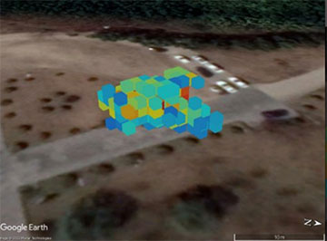
Researchers developed a way to reconstruct 3D images of a leaked gas cloud and overlay the information on a digital map. Red indicates that high concentration of gas is present and blue indicates low. [Image: Y. Hu, Anhui Institute of Optics and Fine Mechanics, Chinese Academy of Sciences]
When toxic gas leaks from an industrial facility, a quick assessment of the location of the leak and the composition, volume, concentration and distribution of the gas is essential to allow authorities and local residents to respond promptly. To aid such efforts, a team of researchers in China developed a method that uses two scanning Fourier transform infrared (FTIR) remote-sensing imaging systems to reconstruct a 3D image of a leaking gas cloud (Opt. Express, doi: 10.1364/OE.460640).
“Previously, when leaks occurred, the specific location and direction the gas was moving could not be determined,” said Yunyou Hu of Anhui Institute of Optics and Fine Mechanics, Chinese Academy of Sciences, and the University of Science and Technology of China, in a press release. “Our method for creating a 3D reconstruction of a gas cloud can be used to accurately find the latitude and longitude of the leaked gas. This information is important for determining who might be exposed and for quickly stopping the leak so that less gas is released into the atmosphere.”
Reconstructing 3D gas cloud
FTIR technology is widely used for sensing, thanks to its highly sensitive, contactless nature; high resolution; and real-time measurement capability. However, using only one FTIR system yields a 2D projection of a 3D gas cloud. While a 2D image can be used to detect the direction of a gas leak, it cannot help determine the specific location of the leakage and fails to provide information about the concentration distribution of the gas.
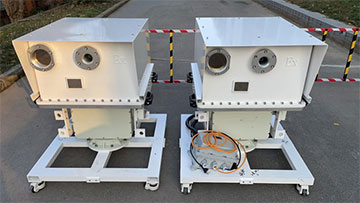
The new method combines information from two remote FTIR imaging systems with precise positioning information from GPS and gyroscope sensors. [Image: L. Xu, Anhui Institute of Optics and Fine Mechanics, Chinese Academy of Sciences]
With the goal of detecting the volume, location, propagation and concentration distribution of the leaked gas cloud, the researchers decided to use two scanning FTIR remote-sensing imaging systems instead of one. Each system consists of an FTIR interferometer, reflecting telescope, industrial camera, two degree-of-freedom pan-tilt platform, GPS, nine-axis gyroscope, interferogram data acquisition and processing system, and desktop computer.
To obtain a 3D image of a gas cloud, the researchers positioned two FTIR systems so that they would point at the same space from different angles. The systems then collected the IR radiation and location data—azimuth and elevation—of a gas cloud. Because the two systems each create a 2D grid from a different perspective, the researchers could construct a 3D grid that provided full spatial information. This grid, combined with spectral data, was subsequently processed using a computerized tomography imaging algorithm called simultaneous algebraic reconstruction technique (SART). The final result of the process is a 3D reconstruction of the gas cloud.
“Each voxel, or 3D pixel, in the 3D reconstructed gas cloud contains 3D information about the gas’s longitude, latitude, concentration and height relative to the ground,” Hu said. “The precise positioning of the monitored space using GPS and gyroscope sensors was key for making 3D quantitative reconstruction of gas clouds possible.”
Real-world tests
To test their two-system method, the researchers carried out a field experiment in the suburbs of Hefei, China. They released high-concentration sulfur hexafluoride (SF6) gas over two minutes in an outdoor space of about 315 m3 while the two FTIR systems simultaneously scanned the space, then they repeated the process with high-concentration methane (CH4) gas. For both gases, the researchers were able to successfully generate 3D recreations of the gas clouds.
The researchers then superimposed the 3D images on the corresponding Google Earth digital map, which is useful for finding the leak source and providing early warning information, the researchers write.
The researchers note that combining multiple scanning FTIR remote-sensing imaging systems and 3D software using the proposed method enables automated, online leak monitoring. They are now optimizing the reconstruction method and planning to test the system in real industrial environments, according to the press release.
