
Scatterings
Did You Know?
Using scanning lidar data to analyze wildfire smoke plumes.
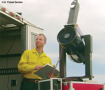 Shawn Urbansky, principal investigator of the smoke plume experiment, with the mobile lidar instrumentation on a U.S. Forest Service truck.
As wildfires have increased in the western United States, it has become important to track the fine particulate and ozone pollution that irritate human lungs and degrade atmospheric visibility. U.S. Forest Service researchers are developing ways to analyze scanning lidar data to determine the height and dispersion of smoke plumes from these blazes (Appl. Opt. 48, 5287).
…Log in or become a member to view the full text of this article.
This article may be available for purchase via the search at Optica Publishing Group.
Optica Members get the full text of Optics & Photonics News, plus a variety of other member benefits.