
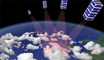
Cloud tomography exploits multiple images captured at the same time to determine the shape, volume and other 3D properties of a cloud. [Image: M. Sheinin, CloudCT project]
Researchers at the Technion–Israel Institute of Technology, Israel, say they have devised a faster and more efficient framework for reconstructing the 3D properties of clouds from the images captured by spaceborne instruments (Intelligent Computing, doi: 10.34133/icomputing.0007). Such detailed 3D analysis is needed to improve the accuracy of climate simulations, which usually rely on remote sensing data to model clouds and the atmosphere as broad and uniform layers.
Accelerated data processing
The study focuses on a particular type of computed tomography (CT) that reconstructs the 3D distribution of scattering objects—in this case, the water droplets and particulates inside clouds. This scattering-based CT technique has emerged over the last decade as a useful method for cloud observation, but the computational cost limits its ability to analyze large-scale atmospheric scenes. That’s a problem for the huge datasets that will be generated by future spaceborne imagers such as CloudCT—now being developed by an Israeli–German consortium that includes the Technion researchers—in which cameras mounted on a fleet of nanosatellites will capture multiple views of each cloud at the same time.
The new data-processing technique speeds up a computational method called inverse rendering, which is widely used in computer vision and graphics to recreate the characteristics of a 3D scene from a series of flat images. However, hundreds of iterations are typically needed to refine the variables that define the scene, which amplifies the inefficiency of the rendering operation itself.
The accelerated algorithm, which the researchers call “path recycling and sorting (PARS),” addresses that problem by reusing the paths from prior iterations to reduce the run time of each new one. Sorting the paths according to size also expedites the rendering process by making more efficient use of the parallel architecture of a graphical processing unit.
Faster, and still accurate
Using synthetic data created for both a single cloud and a cloud field, the researchers showed that the PARS technique can reduce the processing time by an order of magnitude while still yielding an accurate reconstruction of the 3D scene. They also tested the method on eight images recorded at the same time by AirMSPI, a camera that flies onboard NASA’s high-altitude ER-2 aircraft, and found that the algorithm converged on an accurate solution within just 70 minutes.
While the technique is definitely a step toward more efficient cloud tomography, according to the researchers, it does not yet take account of other physical properties that affect the interactions of clouds with the climate, such as the size distribution of water droplets. “PARS should be extended to include microphysical parameters in each voxel to fully exploit the methods of this work for climate research,” the researchers point out. Meanwhile, they believe that the framework could also be used to accelerate other inverse-rendering problems, such as reflectometry and X-ray CT for health care applications.