
Feature
State-of-the-Art Satellite Remote Sensing
The Earth-observation business has undergone a sea change. Commercial firms have launched satellites with sophisticated imaging capability once reserved for classified government specialists. Today, there are more high-resolution satellite images available than ever before—and they are accessible to anyone with an Internet connection.
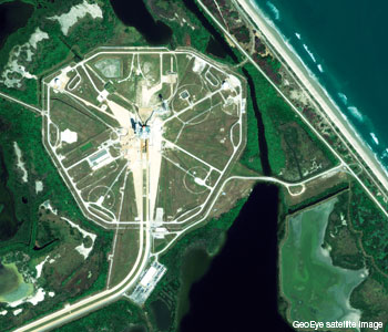 This half-meter resolution satellite image shows the space shuttle Discovery on the launch pad at NASA's Kennedy Space Center, Fla., U.S.A. GeoEye tasked its GeoEye-1 satellite on 1 November, 2010 to capture Discovery before its 39th and final mission into space. According to news reports, this will be NASA's 133rd shuttle mission.
Over the past 10 years, there have been huge changes in the way in which we image the Earth and in how we use the information derived from that imagery. And the future promises even more change. Remote sensing, which for years remained a niche industry, is now a hot technology that is suddenly turning up everywhere—from Google Earth to real-estate markets to the media.
…Log in or become a member to view the full text of this article.
This article may be available for purchase via the search at Optica Publishing Group.
Optica Members get the full text of Optics & Photonics News, plus a variety of other member benefits.
