
[Image: imaginima / iStock / Getty Images Plus]
Scientists have made great strides in deploying optical-fiber-based environmental sensors, but have still faced challenges in using them under Earth’s vast oceans. Signal attenuation limits some fiber sensors to coastal areas, while other techniques only measure perturbations over the entire length of a subsea optical cable, making it difficult to pinpoint signals of interest.
Now a group of scientists based at a British laboratory has converted an existing transoceanic optical cable into an interferometric array of individual sensors (Science, doi: 10.1126/science.abo1939). The team exploited the cable’s existing repeaters to take independent measurements of perturbations of the cable spans between each repeater.
Applying the technique to a 5860-km-long cable between North America and Europe, the group detected two distant earthquakes, one in Peru and another in Oceania. The team also demonstrated that the method works while data traffic passes through other channels of the optical fiber cable—an important consideration when inviting owners of existing transoceanic cables to participate.
Exploiting gratings and repeaters
Previous experiments with methods based on backscattering, such as distributed acoustic sensing, have revealed that the signals from the high-sensitivity technique fade out after 100 km, limiting the use of the technique to that distance from the shoreline. Other recent research employed the phase or polarization change over the entire length of an undersea cable, which can stretch to 10,000 km or more across oceans. Not only does a sensor that long collect a lot of background noise, a single sensor stretching across a long distance is hardly useful for pinning down the precise location of an earthquake.
Instead, Giuseppe Marra of the National Physical Laboratory (NPL), UK, and his collaborators looked at the individual spans of cable that run between repeaters, which amplify optical signals across long distances. Most repeaters use something called a high-loss loop back, or HLLB, that employs a fiber Bragg grating to bounce part of the transmitted light back to the previous reporter along a second fiber.
Finding quakes
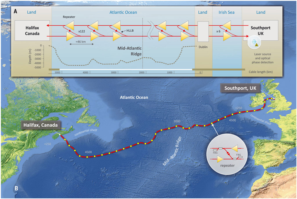
Map of the transatlantic submarine cable from Canada to the United Kingdom. The number of repeaters, 128, was reduced in the figure for illustration purposes. Each repeater has a pair of fiber Bragg grating reflectors, shown in lower inset. Upper inset illustrates the high-loss loop back (HLLB) architecture and cable bathymetry. [Image: Reprinted with permission from G. Marra et al., Science 376, 874 (2022)] [Enlarge image]
Marra’s team sent infrared light from an ultrastable research-grade laser down an optical cable that stretches from Halifax, Canada, to Southport, UK, and contains 128 repeaters along its 5860-km length, with an average repeater-to-repeater span of 46 km. With a photodetector mounted at the transmitter end and high-precision interferometry techniques, the researchers collected HLLB signals from up to 12 repeaters at a time. According to Marra and his teammates, the technique could also work with telecommunications-grade lasers.
When a magnitude-7.5 earthquake hit northern Peru on 28 November 2021, Marra’s team picked it up on six of the nine cable sections on which they were testing. Likewise, a magnitude-7.3 quake in Indonesia registered on five of nine cable sections. In both cases, the researchers were able to figure out the locations of the quakes in agreement with land-based seismometers.
“By converting submarine cables into arrays of environmental sensors, a large network of hundreds or thousands of permanent and real-time seafloor sensors could be implemented without modification of the existing subsea infrastructure,” write Marra and colleagues. “This has the potential to transform our understanding of both shallow and deep processes inside the Earth.”
Besides Marra and his colleagues at NPL, researchers from the University of Edinburgh and British Geological Survey, UK, Google, USA, and Istituto Nazionale di Ricerca Metrologica (INRIM), Italy, contributed to this work.